Location in the world.

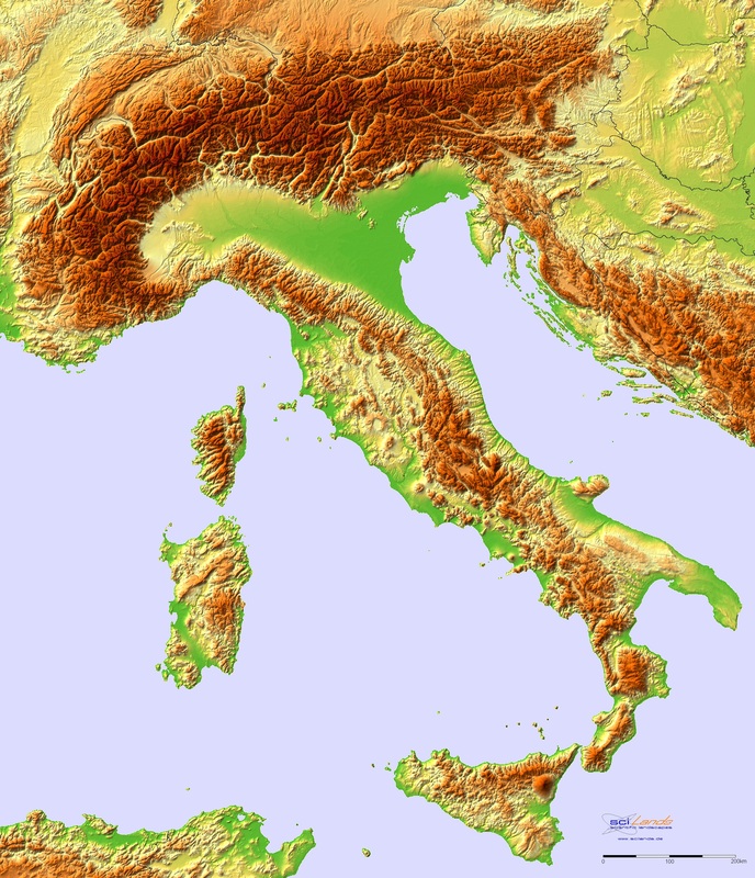
Lombardia is located in the north of the Italian Peninsula and stretches all the down to Naples at its most southern point. It expands over a total of 166 052 square kilometres and is consisting of ten different regions. Lombardia is positioned in the middle of the Mediterranean Sea which gives it prime port cities such as Venice and Naples. These cities lead the nation's international, inter-Mediterranean trade and are extremely important. To continue the country's strong position, it's landlocked sides are in the centre of the European continent. Lombardia's strongest landlocked trade cities are Turin, with it's strong position in the exact middle of the continent. Milan also hails as a strong trade city especially for small fashion companies which deliver inter-continentally. The final major trade city is, of course, Rome. Rome is the capital city and receives the most trade income of all Italian cities due to its large size, population and major cultural varieties.
I chose the location of Italy mostly for the tourism that the country attracts as well as the rich history that I could take advantage of. Furthermore I decided for my country to be based on the peninsula due to the area of Europe having a very good potential for growing a large economy due to the trade mentioned in this paragraph, and some other reasons which will be further explored upon in later parts of my website. I chose to locate my city in the more northern area of the Italian peninsula as it creates stronger ties with the history that I have imagined and will include more tourist areas as it now controls some of the most visited cities and place, for example: the city of Verona, the city of Venice and the Dolomites.
I chose the location of Italy mostly for the tourism that the country attracts as well as the rich history that I could take advantage of. Furthermore I decided for my country to be based on the peninsula due to the area of Europe having a very good potential for growing a large economy due to the trade mentioned in this paragraph, and some other reasons which will be further explored upon in later parts of my website. I chose to locate my city in the more northern area of the Italian peninsula as it creates stronger ties with the history that I have imagined and will include more tourist areas as it now controls some of the most visited cities and place, for example: the city of Verona, the city of Venice and the Dolomites.
|
Lombardia's most northern territories are dominated by the high climbing mountain range that is the Alps. They are most famously found in South Tirol, a highly popular skiing area in the very north of Italy where the Austrian and German affects are highly visible in the population. The rest of the north of Lombardia shares the spectacular -- tourist attracting -- Dolomite Mountain range which also hide away large veins of coal ore as well as the necessary ingredients to make steel. As we travel further south, to around Venice, to as far east as as Milan and as far south as San Marino (which retains its place as a city state), we encounter a massive lowland with nearly no elevations until we meet the state of Tuscany, this is called the Po valley. Here the hilly topographical features return and continue to stretch throughout the rest of Lombardia. As a matter of fact the hills continue all the way into Sicily (which is also independent) until the are finally stopped by the ocean.
The raw resources found in these areas will be: 1. Fresh water 2. Wood 3. Coal I chose these topographical features for my utopia as they provide for beautiful wildlife and sights as well as providing the country with more sources of tourism. Furthermore the large mountain ranges in the north of the country attract millions of skiers on an annual basis while the hilly areas of Tuscany produce some of the finest, and most expensive, wines in the world. The combination of these two factors can once again be used to strengthen my total economy. Finally the mountains coal and steel-production-ores veins can be used for large scale trading especially for the coal, as my countries energy is mostly created by wind and hydroelectric energy which is created largely by dams on the river Tiber and Po.
I chose these three raw resources for reasons of their own. The water should be abundant enough for the entire country to be nourished by it without trade, which is very important in case, in times of war, trade is cut off. Furthermore wood should be the same as water as wood is vital in simple construction and renovation. Coal is the mainly traded raw resource. It has high demand and comes in large amounts in the dolomites, making this anything but a problem. |
Topographical features
|
Lakes and rivers
There are approximately 1200 lakes in Lombardia with the majority lying in the north of the country in the Alpine regions. The 5 largest lakes in the country are:
1. Lake Garda. This lake is located in the north of the country at the borders of Lombardy, Veneto and Trentino Alto Aldige. It is the third largest lake in the alps and is visited by thousands of German and Austrian tourists every year. The lake is gifted with warm, Mediterranean whether and can grow olives on its southern bank, making it ideal for agriculture.
2. Lake Maggiore. This lake is the mark of the border between the two Lombardian states of Piedmont and Lombardy, with the lake also passing into Swiss territories at its northern areas.
3. Lake Como. The third largest lake of the country is also located in the north, about 25 miles south of the major city of Milan which causes many local travellers to go there to escape the stress of the city.
4. Lake Trasimeno. This is the largest lake south of the Po valley, it is most infamous for the battle that was fought there in 219 BC when Hannibal crushed a Roman force of 15 000 in a powerful victory. The lake is extremely shallow at just six meters deep at its deepest points.
5. Lake Bolsena. This lake is located in the state of Lazio, in a hollow crater of a long dead volcano.
The Italian peninsula is an area of many rivers, the five biggest of which are:
1. The River Po. This river flows either 652 Km or 682 Km if you were to include the length of its tributary, the Maira. It flows at a discharge of 1540 meters per second cubed and discharges into the Adriatic sea. Its source are the Cottian Alps.
2. The River Adige. This river flows for a total of 410 Km. Much like the River Po the River Adige also opens into the Adriatic Sea (the sea on the eastern side of the Italian Peninsula.
3. The River Tiber. This river flows for a total of 405 Km and mouths into the Tyrrhenian Sea with its source being the mountain "Mount Fumaiolo".
4. River Adda. With a discharge of only 318 meters per second cubed, the river Adda is quite slow-flowing especially in comparison to the river Tiber which runs at almost five times that speed. The Adda runs for 313 Km and mouths into the River Po.
5. River Oglio. The Oglio runs for 280 Km and is even slower than the Adda discharging at only 130 meters per second cubed. Its source is the Corno dei Tre Signori (a 3360 meter high mountain in Lombardy) and it too mouths into the Po River.
These resources of water give a very clear justification as to why I chose the geographic position that I chose. The lakes in the north of Italy are large and attract a lot of tourism due to their natural beauty as well as having arm climates to easily enable agricultural on the rich banks of the rivers, which create two major sources of income. The rivers help strengthen my idea of having a more clean way of producing energy as rivers like the Po or Tiber seem perfect for hydroelectric energy uses. This will cut down on the coal and therefore carbon emissions in the energy production, which is useful for my social progress index scores.
Weather
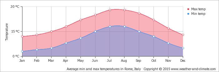
The Mediterranean climate that is seen in Lombardia usually does not drop below 0 degrees Celsius ever with temperature graphs showing numbers more resembling of 5 degrees minimum to 15 degrees maximum in the coldest couple of months. The warmest months averaged at around 17 degrees minimum and around 28-29 degrees maximum in the summer. These temperatures show very clearly how the Mediterranean climate is perfect for outdoor activities all year around.
I chose this kind of biome/ weather due to tourism being an all-year-around money-making source even in the non-skiing areas of Italy. Furthermore these kind of temperatures could, in the best case scenario, allow farmers to farm some plants that may not need to much warmth or sunlight to grow, which makes being a farmer not just more profitable, but more of a viable and maybe even more popular job.
